









After several days of warm temperatures and increasingly dry conditions across Southwest Montana, residents of Butte and surrounding communities are preparing for a dramatic shift in the weather pattern as a slow-moving storm system settles over the region for the weekend.
Forecasters are calling for widespread rain, cooler temperatures, and even mountain snowfall in some higher elevations as a large area of low pressure moves inland from the West Coast.
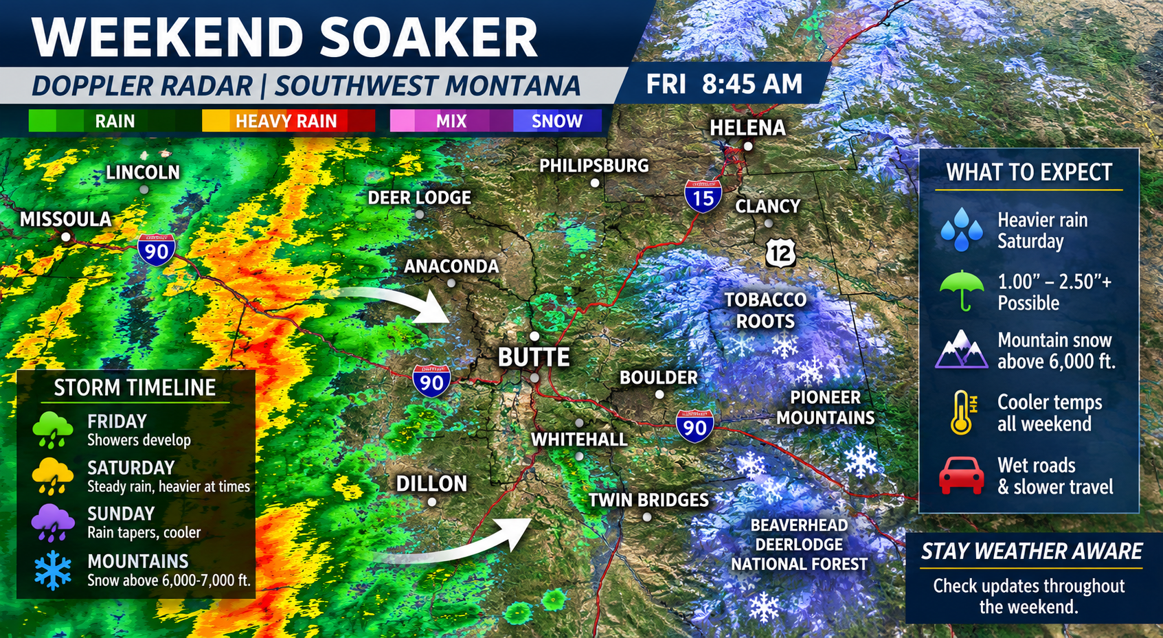
The system is expected to linger for several days, bringing what meteorologists often call a “soaker” event — a prolonged stretch of steady precipitation capable of delivering meaningful moisture to the landscape.
For many residents, the timing could hardly be better.
While spring has brought periods of rain to portions of Montana, recent stretches of sunshine and warmer temperatures have begun drying soils throughout parts of Silver Bow County and nearby areas.
Lawns have greened, farmers have begun field work, and outdoor recreation has increased as residents take advantage of the warmer conditions. However, concerns about long-term moisture levels and wildfire potential remain fresh in the minds of many Montanans.
The upcoming storm is expected to provide a meaningful boost to soil moisture levels while also helping reduce immediate fire danger across much of Southwest Montana.
Weather experts say the storm originates from a stalled low-pressure system that has been spinning over portions of California and Nevada. As the system gradually shifts eastward, it will pull moisture northward into Montana while drawing cooler air into the region.
The result is expected to be several days of cloudy skies, periods of rain, and noticeably cooler daytime temperatures compared to what residents experienced earlier this week.
In Butte, residents can expect temperatures to fall well below recent highs. Instead of sunny afternoons and temperatures approaching the 70s and 80s, daytime highs are expected to remain considerably cooler under persistent cloud cover.
Travelers planning weekend trips through the mountains may encounter reduced visibility and wet roads, especially during heavier bands of precipitation.
Higher elevations in the Tobacco Roots, Pioneer Mountains, Highlands, and portions of the Beaverhead-Deerlodge National Forest could see accumulating snow at the highest peaks.
Although late-May mountain snowfall may seem unusual to visitors, longtime Montanans understand that winter weather can linger well into spring at higher elevations.
The anticipated rainfall is welcome news for ranchers and farmers throughout the region. Adequate spring moisture plays a critical role in pasture growth, hay production, and crop development throughout Southwest Montana.
Local gardeners may also benefit from the soaking rain. Across Butte, Anaconda, Deer Lodge, Dillon, and neighboring communities, many residents have already begun planting flowers, vegetables, and landscaping projects following a relatively mild spring.
The wet weather may create challenges for some outdoor events scheduled this weekend. Event organizers may need to monitor conditions closely and make adjustments if rainfall becomes persistent.
For recreational enthusiasts, the storm presents both opportunities and inconveniences. Anglers may benefit from improved stream flows and cooler water temperatures, while hikers and campers should prepare for muddy trails and changing mountain conditions.
Those venturing into the backcountry are encouraged to carry appropriate rain gear and remain aware that weather conditions can change rapidly in Montana’s mountains.
The moisture could also provide a temporary reprieve for firefighters and land management agencies. While fire season has not yet reached its peak, spring precipitation helps delay the drying of grasses and vegetation that often fuels summer wildfires.
That said, one storm will not erase all wildfire concerns. Long-term drought patterns, summer heat, and future precipitation will ultimately determine how severe Montana’s fire season becomes.
In Butte, rain has always been part of the region’s story. The city’s history is filled with accounts of miners working through storms, railroad crews battling difficult weather, and residents adapting to the challenges of life at high elevation.
As the storm settles in, umbrellas may become a common sight throughout town. Windshields will need frequent wiper use, and outdoor plans may move indoors.
When the storm eventually departs and sunshine returns, the effects should be visible across the region. Hillsides should appear greener, streams may run higher, and dust levels will decrease.
For now, residents throughout Southwest Montana should prepare for a wet and cooler weekend. Rain gear, waterproof footwear, and a little flexibility may be useful companions over the next several days.
As May gives way to June, Southwest Montana appears poised to receive one of its more substantial precipitation events of the season — a reminder that spring in Montana remains unpredictable, powerful, and essential to the landscape that defines the Treasure State.
